Monday, April 24, 2017

Little Vietnam

I went to little Vietnam this past weekend with my buddy Barrett. It was quite the trip. When we were getting close to the area I noticed and increase in asian people from stopping at the gas station. I watched as slowly the Business names had more and more Vietnamese writing. The sub region of Little Vietnam was very apparent. Overall a great experience it was interesting being the minority rather than the other way around. Every one we met was very friendly. I loved being immersed in that culture so close to home.

Documentation:
Hens 15$ Roosters 10$

Most of the Women wore this style hat

Barrett Posted in front of the fresh fruit

Inside the Market

Fresh Fish was a hot commodity

Fish

Barrett and local Vietnamese resident

Filleted Fish

We decided to purchase the Authentic hats 5$ per

Culture Crossing the World

Catholic Religion

Monday, March 27, 2017

Abandon Airfields (Foundation Project)


  1. Lucien Airfield
  2. Hodges Airfield
  3. Ruston Airport
  4. Baton Rouge Downtown Airport
  5. New Orleans Callender Field
  6. Picayune Municipal Airport
  7. Hanncock County Airport (Bay St. Louis)
  8. Port Eads Airstrip

1. Lucien Airfield - It started with a 3000' unpaved runway. It was a busy little airport owned by Jim Clark. The airport switched owners many times throughout the years. At one time in 1962 there were 18 aircraft based on the field. The airfield served as a general aviation strip with some basic flight instruction in Cessna 150s and C172s. In 1996 a tornado hit Lucien Field leaving all but two of the hangars on the field. The field was then abandoned in the early 2000s.
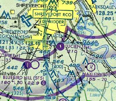
Memphis Sectional depicting Lucien Field
as a private airstrip.


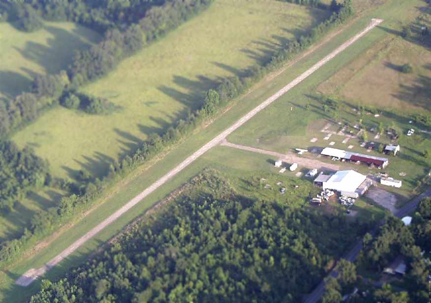
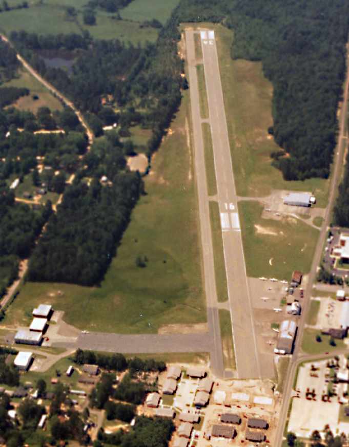
Lucien field in 2004


2. Hodges Airfield - Located about 6 miles southeast Florien Louisiana Hodges is made up of two runways a north south and east west runway. It was labeled abandon on the 1998 world aeronautical chart. This small airfield most likely served as a place for local pilots to enjoy some off airport landing.
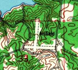
Hodges Airfield 1954 USGS Topo
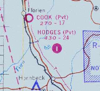
Hodges depicted as private airfield 1967 Beaumont Sectional
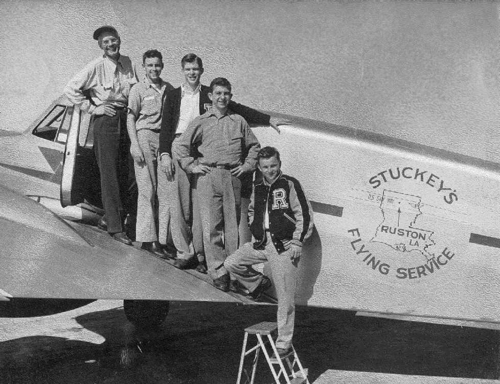
3. Ruston Airport - This airport was once a cow pasture designated by the Civil Aeronautics Administration as an emergeny landing field along the U.S. Skyway One. Savery L. Stuckey was the man to put the airport into operation in 1945 when the first paved runway was constructed. He opened up a flight school and was said to have trained 1000 pilots to fly. The airport flourished over the years. Louisiana Techs aviation program was started at this airport. It stayed in operation until 1994. The airport was closed due to its proximity to the town and the need of the land for other uses.
Ruston
Airport
Circa 1994

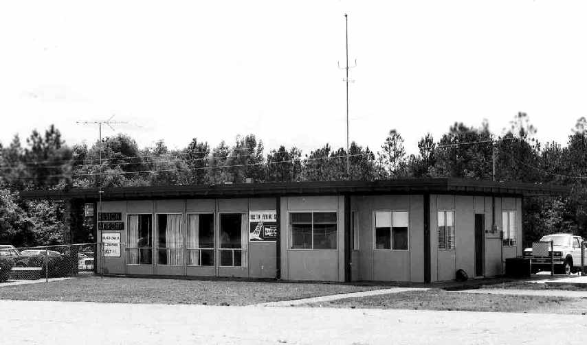
Ruston Airport Terminal 1980


4. Baton Rouge Municipal Airport - The Baton Rouge airport was opened in 1931 it was nothing more than a 56 acre turf field. Some where around 1963 the airport was renamed the Baton Rouge Downtown Airport. In 1972 the Downtown Airport had two 3000 ft paved runways.The Last sectional map withe the downtown airport in operation was the 1975 Houston Sectional. The Baton Rouge Downtown airport closed due to the encroachment of commercial businesses the land was so valuable that they could not justify keeping the general aviation airport. Tpday the only reminince of the old downtown airport is the Large hangar at independence park that was reclaimed as a recreational facility.
BTR Airport 1940's
Houston Sectional 1975
Last remaining Hangar (Modern Day)


5. New Orleans Callender Field - The site for this aiport was cleared some time in the 1920s because of a nation wide tour that Charles Lindbergh was giving. It was depicted as an airfield on the USGS 1932 topo. The name was the Wedell Williams Landing Field a square patch of land with 3 unpaved runways. 1940 the airport was listed on the USGS Topo as Alvin Callender Field. In 1957 the Navy needed a replacement field for larger jet aircraft. They chose the sight just next to callender Field soon after the field closed. Last depiction New Orleans Sectional 1956.
1950 USGS Topo


2002 Aerial View Runways still Clearly Visible.


6. Picayune Municipal  - Airfield just west of Downtown Picayune had a single 4000' Paved runway a simple municipal airport that service the community. Constructed sometime in the early 1950s. In 1999 the new Picayune aiport was opened. which lead to the abandonment of the old airfield.
1985 USGS Topo

1966 Mobile Sectional
1996 Aerial Photo


7. Hanncock County Airport - A small airfield just west of the Bay of St. Louis. It was a 2200' grass runway running northwest - southeast. This landing strip was evidently made somewhere between 1949 and 1952 it showed up on the 1956 USGS Topo labeled as Airfield.
1956 USGS Topo 
1964 NASA aerial photo


1965 New Orleans Sectional Chart


8. Port Eads Airstrip - A 2000' grass srip at the mouth of the Mississippi River on the North side of the Pass across from the lighhouse. It was originally built and maintained by Plaquimenes pairsh years ago. It was used to support the fishing and hospitality industry. It was abandoned by the parish for liability reasons. It floods easily but is in acceptable enough condition to operate small aircraft out of.
Port Eads Airstrip

Port Eads Marina
Port Eads 


My Abandon Airports project was one of my favorite projects I have done all year. Researching the airports and their history has been quite interesting. General Aviation although not always apparent to the public has an extremely large infrastructure throughout the United States and Airfields through the years were opened and closed all the time. Today the number of small airports and airfields is on the decline which is why I found it interesting to see all of the abandon fields that surround the area that I live. On my map I show were these airports are located and where the New airport for that location is located.  As cities and towns grow the valuable land that these small airports occupied was no longer justified during the downturn of General Aviation so the property was reclaimed a lot of times and used for other things. From the time aviation really took off after WW1 almost every little town across the US had some sort of landing strip. Most are Long gone now but a lucky few of these old landing sights remained in tact and recognizable today. Aviation since the early days has not been only used for pleasure but for business and traveling to and from different locations around the U.S. The vast network of Airfields made this possible to get to remote locations not accessible by large airports. General aviation is a tight nit community every where you go it has a cultural uniqueness that stands out no matter where you fly in the United States. At a given point in time you could fly to one of these abandoned field and find a group of people that loved aviation just as much as you. You could find camaraderie and friendship all over. It is culturally homogeneous even spanning thousands of miles across the country. The type of flying that you get varies geographically as the terrain changes but the passion does not. With general aviation on the decline  researching abandon airports like these allows you to see the once thriving scene of general aviation and how these fields dotted the landscape. From the air you will see the landscape like no one else can you will notice things that only birds can see. The first place to start when traveling upward is at an airport. 


Citations- 
All data gathered from Abandon & Little-Known Airfields a site built by Paul Freeman this data base contains information on 2,171 airfields in all 50 States.

Wednesday, March 15, 2017

Little Vietnam Points of Interest (Field work prep)


The map above is a template for my upcoming Field trip to Little Vietnam. I have marked many places of interest that i think can give me a better idea of what this community is about and how the culture differs from the surrounding New Orleans area. I am most excited about visiting the Veggie Co-op and getting to see the wide variation of produce they have and maybe even buying a few things to cook for dinner. You can tell a lot about a person or a culture by their cuisine which is what i intend to investigate on my visit. The supermarket is another great place to possibly do some interviews but also to just people watch. I marked the two of the religious establishments in the area: The Buddhist temple, and the Vietnamese Marry Queen Church.I have multiple Polygons of backyard gardens, some still in production and others that have since been grow over. I am bringing my bike and plan to cruise through the entirety of the enclave to get a good view of all the people their homes and a look at a day in the life of the Vietnamese and others living in this unique region of New Orleans.

Friday, March 3, 2017

Haitian Place


Any country has struggles through out time as it grows, but Haiti has had more than its fare share. Being an island nation occupied by many different groups who exploited the countries resources and people and located centrally to one of the most active Hurricane areas in the world Haiti has experienced a large amounts of heart ache.  The last natural disaster the earth quake of January 12, 2010 that came and reeked havoc on the city of Port Au Prince really made an impact on the people. Before the earth quake it was already a poor country and after things just continued to fall apart. Haiti is a place that is shaped by its natural disasters. Looking at these three locations it gives you an idea of the culture of the country some what torn but long standing because of its resilient inhabitants. The jail a representation of its broken democracy and the gap between the haves and the have nots. The statue in the Place du Marron with that through out all the hardships stands strong and To cap it all off the beautiful palace that stands strong but only to be toppled by a devastating earthquake.

Wednesday, February 22, 2017

Mobility II


The Atlantic Ocean Acts as an extremely large barrier but one that is permeable. With the trade of goods and people from Africa, Europe, to the Americas much was transferred and lots was lost in the crossing through diffusion. This particular map Shows voyage routes from of Haast U Langzaam a frigate vessel from 1777 to 1778. More specifically if zoomed in on the paths you will see certain skull and cross bones designating deaths of slaves on particular dates. I have labeled two important ports the Elmina Slave Castle in Ghana and Fort Zeelandia in Suriname. This is an interactive map so by clicking on any of the icons you will be blessed with loads of data on each entry. We also have the Paths and category of Hurricanes in 1898.

Thursday, February 16, 2017

Rice Mobility


Plots
East Coast US (widths)
West Coast Africa (widths)
1
Hampton Island 2500’
Field 1 (1 section)
1800’
2
Magnolia Plantation
2700’
Field 2 (large River Bend)
1000’
3
Field 3
6000’
Field 2 (one plot in a vast island of fields)
150’
4
Field 4
1000’
Field 4 (corner lot in dog leg of river)
250’
5
Field 5
3500’
Field 5 (set between two flows Narrow Field)
220’ x 550’


South Carolina Rice Field tended by slaves.


Modern day South Carolina Rice Field


West African Rice Field Levee system
West African Rice Field


My Rice fields on the east coast of the USA are located in and around the Charleston, South Carolina area. Some fields are still in use others are from the distant past located around old plantation sites that are now just bodies of water. On the Western Coast of Africa I chose fields across the river from the most notable city of Bissau, Republic of Guinea Bissau. These fields are located around large rivers and small inland tributaries the fields are sectioned off into smaller plots. The expanse of the fields in western Africa is much larger than that of the east coast but the style is quite similar. I noticed that on the east coast the fields were not sub divided as much as the ones in Western Africa.You can see the diffusion by the location and shape of the fields from West Africa to the the United States East coast. By examining my embedded map you will see the location and distance of my fields from place to place and how they differ. Both locations of the fields are coastal along notable flowing rivers that are no doubt affected by the tides.Which is essential for the operation, and the style of fields that have been developed. This tidal rice cultivation was unique to West Africa and without the transport of Slaves to South Carolina and with out their expertise in the formation and infrastructure involved in using tidal cultivation the rice industry would never have thrived in low country South Carolina as it did.

Friday, February 10, 2017

Dixie Divided


I divided my Dixie into Regions based on geographic features that shape particular areas combined with economic drivers for certain sub regions. I compiled these regions based on common knowledge of areas around the south. Where we live and what we do shapes who we are although Garreau lumped all of Dixie into one area living through out the south we know how different each sub region can be. Some areas are much larger than others because of wide spread geographic similarity. The Gulf south having primarily oil and gas manufacturing with some fisheries. If you click on each of the colored regions it gives you a specified name.


  • Brown - Gulf south oil and Gas 
  • Orange  - Eastern Pines lots of ag forestry
  • Dark Green - Ozark mountains hill country hick country
  • Blue (western) - manufacturing - Aerospace and transportation 
  • Light Green - Mississippi River Delta Agriculture and shipping along the river Fertile flood plain
  • Red - Deep eastern Mississippi (the most over weight state in the union)
  • Blue (central) - Nashville area country music scene
  • Purple - Ohio river valley 
  • Yellow (North Central) - Hilly rural Indiana
  • Black - Coal country
  • Light Purple - Appalachian Country this is a rural area with mining and some recreation due to the national forest.
  • Yellow - Piedmont plateau between the Mountains and the coast heavily populated.
  • Blue (eastern coast) - the outer banks/the southern end of the eastern seaboard tourism shipping lots going on shaping these people.
  • Purple (central florida) - dominated by orlando and the disney land culture
  • White - white sands beaches of the Florida huge economy based around the beach and vacationing
  • Light Orange - North pan handle, south Alabama and Georgia. This is deep south territory.